The Parish of Brentor, Devon
Please note that this page is being updated and redesigned
Location & setting
The parish of Brentor is situated in West Devon, about 4 miles (6km) north of the market town of Tavistock on the north west edge of the Dartmoor National Park. To the east is the River Burn (a tributary of the River Tavy), and Gibbet Hill backed by an impressive range of granite Dartmoor Tors. To the north and west is the River Lyd (a tributary of the River Tamar) and an 'area of outstanding natural beauty' in the Lyd Valley.
The Tor itself is a dramatic conical volcanic plug 1100 feet (335m) high. In contrast to the neighbouring granite tors of Dartmoor, Brent Tor was formed from pillow lava extruded under a shallow sea some 350 million years ago. The result is an 'excellent and rare example of ...submarine volcanic deposits' and has been registered as a site of special scientific interest (SSSI).
Blocks of lava and pumice have been incorporated into many of the stone walls and houses in the parish.
The prominent and rugged nature of Brent Tor has made it a focus for human activity for more than 2,000 years. Notable earthworks around the Tor include late iron age ramparts dating from 500BC, and later enclosed platforms probably established in the Dark Ages or the medieval period. These earthworks constitute a scheduled monument.
The most striking human feature is the 12th century church of St Michael de Rupe, which is both the smallest and highest complete parish church in England. This early Norman chantry was built in 1130 by Robert Giffard on the summit of Brent Tor, giving it a unique and dramatic silhouette. The church is only 4.6 metres (15 feet) wide and 11.3 metres (37 feet) long, with a 12.2 metre (40 foot) tower housing three bells. St Michael's remains the official Brentor parish church despite the later construction of Christchurch in North Brentor
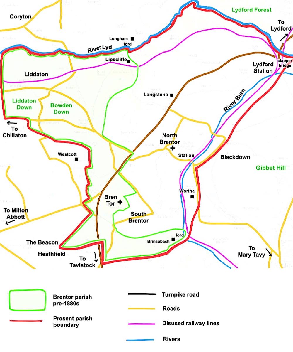
Map 1 - Parish map showing changes in boundaries and locations of settlements
The parish
The current parish has an area of 13.46 sq km and the population was estimated to be 385 in 2020, in 220 households centred on the village of North Brentor.
Smaller numbers are distributed in the surrounding hamlets:
To the south - South Brentor, close to Brent Tor.
To the west - Liddaton, in the Lyd valley.
To the north - Lydford Station (Lydford Junction).
There are also numerous outlying houses and farms. With the exception of Liddaton all the settlements are within the Dartmoor National Park.
The agricultural settlements were connected by a network of rugged routes for pack horses until the late eighteenth century, when the demands of the industrial revolution triggered extensive enclosures of common land and demands for raw materials. Mining for manganese, ochre and copper became important sources of wealth and employment in the nineteenth century, with at least five mines active in the parish. These developments resulted in the construction of a turnpike toll road past Brent Tor in the late eighteenth century and of two railway lines along the Burn valley in the nineteenth century.
Boundary changes
The resulting changes in the local economy affected the livelihoods and distribution of the population and triggered major alterations to the parish boundaries and to the main population centre at North Brentor.
Prior to the boundary changes of the 1880s, Brentor parish was a relatively thin sliver of land encompassing Brent Tor in the south and reaching up to the River Lyd in the north. Its only settlement was Liddaton, since both North & South Brentor and Lydford Station lay in a detached portion of the neighbouring Lamerton parish.
White's Directory of 1850 describes Brentor as 'containing 169 souls, and 2180 acres of land, rising in bold hills on the western confines of Dartmoor'. The parish church was St Michael de Rupe (at the summit of Brent Tor).
The boundary changes of the 1880s (ecclesiastical boundary change 1883, civil boundary transfer 1885) transferred the detached portion of Lamerton to the Parish of Brentor, more than doubling its size and population. Further boundary changes in 1987 saw the area east of the 'White Lady Waterfall' on the River Lyd transferred to Lydford parish and Blackdown, up to the road, transferred to Brentor from Mary Tavy parish.

North Brentor map, showing key buildings

Christ Church, Brentor, Devon

Old Methodist Chapel, Brentor, Devon

Methodist Chapel Organ, Brentor, Devon

Miner's Cottages, Brentor, Devon
.
Brentor Village Hall, Brentor, Devon
Transport and Communications
Turnpike road
The turnpike road from Tavistock to Lydford (see map 1) was opened in 1762, with a Toll House at 'Riccard's House' (Brentor Inn). There were four gates where the pack horse track from Mary Tavy to Coryton crossed the turnpike road. The Tavistock Turnpike Trust was wound up in 1867, following the completion of the railway line from Tavistock to Launceston along the Burn Valley. (From information given in 'Tavistock's Yesterdays' vol 3, pages 17-36 by G. Woodcock)
Railways
South Devon Railway (linked to GWR)
The South Devon Railway built a goods siding but no station in Brentor on its Tavistock to Launceston line in 1865. This later became a GWR line with a station opened at Lydford Junction (also in Brentor Parish, E on Map 1.) in 1876. A joint SDR LSWR goods yard at Lydford was used until 1879. (From information given in ‘The Okehampton Line' by J Nicholas G Reeve, Irwell Press Ltd)
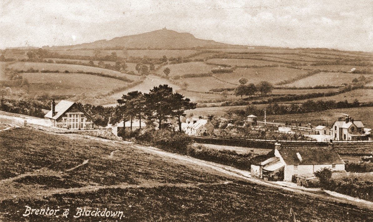
Brentor Station and School House, circa 1910
Brentor Station (LSWR)
A double track line opened for goods traffic on 12 May 1890 to the east of the GWR line and parallel to it. Brentor Station opened for passenger traffic on 2 June 1890. This was the busiest station on the LSWR line
between Tavistock & Okehampton..... The LSWR line was one of the main routes from Plymouth to London. The goods yard was closed on 4 April 1960 and the signal box on 10 June 1961. Both the line & station were closed on 6 May 1968 following the Beeching 'rationalisation' of the railway system. (From information given in ‘The Okehampton Line' by J Nicholas G Reeve, Irwell Press Ltd).